Understanding the geography of Egypt is essential for planning your trip to this beautiful country. With vast dimensions and diverse landscapes, Egypt offers a unique travel experience, from the arid desert lands to the fertile Nile valleys and the stunning coastal views of the Mediterranean and Red Sea. In this guide, we provide information on Egypt’s location, bordering countries, major natural regions, and administrative divisions. By gaining a better understanding of Egypt’s geography, you’ll be able to form a mental map and plan your journey to the land of the pharaohs with ease.
Egypt is located between two continents, making it unique. The majority of Egypt’s territory is in the northeastern part of Africa, while the Sinai Peninsula is in Asia. With over one million square kilometers, Egypt is approximately twice the size of Spain. It shares borders with four countries:
A curious fact about the borders that delineate the geography of Egypt is that its southwest end is a tripoint, i.e., a point where the boundaries of three different countries converge: Sudan, Libya, and Egypt. This point was not chosen by chance, as it is full of symbolism: it is Mount Uweinat, with prehistoric rock engravings that represent animals and animal figures, made by Bushmen tens of thousands of years ago.
Another important feature of the geography of Egypt is the significance of its coastlines, which cover almost 2,500 km in total. They are bathed by the waters of two different seas: the Mediterranean Sea to the north and the Red Sea to the east of the country, in the African and Asian parts of the country. These two seas, by the way, are connected to each other thanks to the extraordinary engineering feat that was the Suez Canal, a milestone in world maritime navigation in 1869.
Understanding the geography of Egypt goes beyond its administrative division. It can be divided into large natural regions, each with significant differences and of great interest from a tourist point of view. Knowing and locating these regions is crucial, as the terminology used to refer to them is varied and sometimes confusing. Becoming familiar with these regions will allow you to make informed decisions about the destinations to visit or the route to take on your tour. Here are the main regions:
The Nile Delta is a large portion of land that forms at the mouth of the Nile River, taking on a triangular shape on maps of Egypt’s geography. The ancient Greeks gave it the name Delta, like the Greek letter (Δ), due to its shape.
This unique shape is a result of the Nile River dividing into two almost symmetrical branches to the north of Cairo, known as the Rosetta branch and the Damietta branch. The distance between the two estuaries is around 160 km, but the total length is measured from Alexandria at the western end to Port Said at the eastern end, which gives a distance of approximately 240 km.
The lands on either side of these branches are highly fertile and suitable for agriculture, providing a sharp contrast to the surrounding arid desert lands. As a result, the Nile Delta is a heavily populated area, with an estimated 40 million people living here – almost 40% of the country’s total population. The population density is about 1,000 inhabitants per square meter outside of urban areas, and over 50,000 inhabitants per square meter in some cities. Notable cities in this region include Alexandria, Port Said, Tanta, El Mansura, Damanhur, and Zagazig.
Cairo, the capital of Egypt, is a megacity that forms a region in itself within the country’s geography, both administratively and urbanistically. The city is an immense metropolis with a mix of skyscrapers and mosque minarets, and its metropolitan fabric extends beyond the traveler’s line of sight, leading to what many experts call hyper-urbanization.
With approximately 8 million inhabitants in its municipal area and 16 million in its metropolitan area (although other sources estimate this figure to be as high as 20 million), Cairo is the largest urban concentration in all of Africa and one of the largest in the world.
While Cairo is not geographically in the center of the country, it is considered the center of Egypt because it serves as the link between the Nile Delta and Upper Egypt. Although the terrain in this region is similar to that of the Nile Delta and Upper Egypt in terms of fertility, Cairo’s urban development has made it a hub for the service sector, with the city serving as the financial and economic center of the country.
In addition to being a major economic center, this region includes other cities that house some of the country’s most popular tourist attractions, such as the Pyramids of Giza, the Pyramid of Saqqara, and the Necropolis of Memphis (which today is part of the population of Mit Rahina). The capital also offers a wealth of attractions, including the Egyptian Museum and the historic center of Cairo, making it an essential stop on any tour of Egypt.
Upper Egypt is a long and narrow natural region that follows the fertile Nile Valley from the Fayum Oasis, south of ancient Memphis, to the first cataract of the river at the height of Aswan, covering a distance of approximately 850 km. On either side of the river, the fertile surface of the plain emerges, extending between 1 km to 20 km in a linear sense depending on the stretch.
It’s important to note that Upper Egypt should not be confused with the Upper Nile, which refers to the first stretch of the river and is not part of Egypt’s geography. The Upper Nile consists of two branches, the White Nile and the Blue Nile, which run through eastern Africa (Ethiopia, Uganda, Tanzania, Kenya, etc.) before converging in Khartoum, Sudan. In contrast, the Lower Nile refers to the entire river course located within Egyptian territory, which represents only a small portion of the Nile’s total length of over 6,800 km from its sources.
This region is one of the most attractive areas in Egypt, not only for its numerous preserved monuments from ancient Egypt but also for the unique way in which they can be discovered: aboard cruises of various sizes that typically travel up the waters from Esna to Aswan. Our main route follows this path, but with an added twist – we’ll be sailing on a luxury dahabiya, a traditional sailing vessel that adds a special charm to the experience.
Middle Egypt is not an official subdivision on any map of Egypt’s geography, but it has historical significance and is still informally or unofficially used by Egyptians today. This region encompasses the Nile Valley from the north of the Fayum Oasis to the city of Asiut in the south.
In terms of tourism, Middle Egypt is home to historically valuable monuments and cities that attract many visitors, such as Amarna, Asiut, Abidos, Dendera, and the Fayum Oasis.
It’s important to note that Middle Egypt should not be confused with the Middle Kingdom of Egypt, which only refers to a historical period of Ancient Egypt from around 2050 to 1750 BC and has no geographical implications.
Nubia is a historic region that spans Egypt (Lower Nubia in the south) and Sudan (Upper Nubia in the north). Lower Nubia lies between the first Nile cataract and the Sudanese border, close to the second cataract in Sudanese territory. Although it is not an administrative division in either country, it is enclosed within the Aswan Governorate on maps of Egypt’s geography.
Lower Nubia is often referenced during trips to Egypt, particularly on Nile cruises, as much of the route runs through an area that was once an independent kingdom. It still has distinct characteristics and customs, such as its architecture and ancient languages, which hold significant historiographical value, as ancient Nubia is considered one of the cradles of civilization, along with Mesopotamia and neighboring Ancient Egypt.
However, many of the villages in Lower Nubia were submerged in the mid-20th century due to the construction of the Aswan Dam, which substantially altered the geography of southern Egypt by impounding the waters of the Nile in Lake Nasser, raising the river channel by several hundred meters. This forced most Egyptian Nubians to relocate to other locations such as Elephantine Island in Aswan and various cities in the country.
Today, Lower Nubia is dominated by Lake Nasser, presenting a different landscape than the rest of the Nile Valley. The mass of water in this large swamp is wider and more confined, without the existence of fertile meadows on its sides, as its shores are more rugged and its soils not alluvial, having been artificially generated.
The desert, along with the Nile and the coastal areas, is one of the great natural elements of Egypt’s geography. In fact, there are two deserts, with the largest being the Western Desert, which is actually the eastern portion of the Sahara Desert and stretches from the border with Libya in the west to the left bank of the river in the east. It occupies about two-thirds of the country’s total surface area, so its immensity is difficult to imagine if you have never been there. It covers more than 650,000 square kilometers, where it is possible to find vast expanses of golden sand dunes, such as the Great Sand Sea, or whimsical geological formations, such as those of the White Desert, whose name reflects the deceptive color that tricks tourists – it looks like an infinite blanket of snow, and some call it ‘Egypt’s Alaska’!
Therefore, it is a inhospitable and arid terrain in most of its territory, but perfect for experiences related to extreme solitude and tranquility, such as meditation and yoga trips. Its overwhelming silence and clear sky, pure during the day and starry at night, are inseparable companions of those who venture into it.
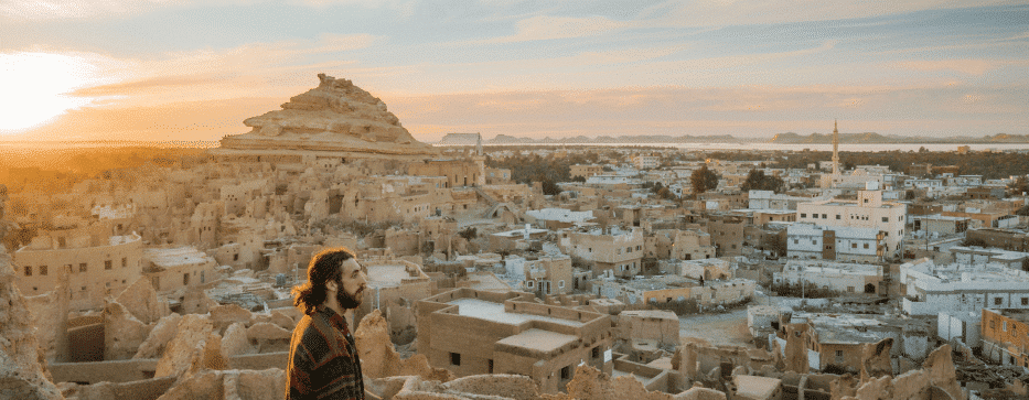
However, in this Western Desert, spectacular oases emerge almost as if by magic, the result of underground embalmed waters. They have been very characteristic elements of Egypt’s geography for millennia, making life possible. And for the delight of tourists, they offer landscapes of surprising beauty. This is the case, for example, with the famous Siwa Oasis, but also with many others such as Bahariya or Dakhla, which our agency can take you to.
Egypt’s geography is also shaped by the Eastern or Arabian Desert, which extends to the east of the Nile and covers other countries to the south (Eritrea and Sudan), as well as the Sinai Peninsula, located on the other side of the Red Sea. This terrain is even more inhospitable and arid than the Western Desert, with hardly any oases that provide water and minimal fertility to the land. However, numerous wadis, which are dry riverbeds that only carry water during certain periods of the year or as a result of occasional precipitation, can be found here.
The terrain here is more rugged and mountainous, with a mountain range that includes the highest peaks in Egypt, reaching or exceeding 2,000 meters in some cases, such as Shaiyb al-Banat (2,187 meters above sea level). The same applies to the Sinai Peninsula, where natural elevations are even higher (Mount Catherine, 2,642 meters above sea level), more spectacular, and more legendary. Mount Sinai (2,285 meters above sea level) is famous for being the site where God gave Moses the tablets of the Ten Commandments, according to the Bible’s Exodus. It is also an area of interest for Christianity, with important temples such as the monasteries of St. Anthony, St. Catherine, and St. Paul. Our agency can organize pilgrimage trips to this area.
The Sinai Peninsula is easy to spot on a map of Egypt’s geography, as it is the large triangular piece of land that lies in Asia. This peninsula was returned to Egypt in 1982 under the Camp David Accords signed with Israel, which occupied it for a decade and a half.
Egypt boasts a coastline of almost 2,500 km, showcasing diverse natural and human landscapes. Both coastlines are prime examples of the country’s significant tourist development in recent decades, which has led to a remarkable diversification of the sector. While it was once solely possible to explore the historical period of Ancient Egypt or experience the hustle and bustle of the bustling cities of the Nile Delta and Valley, nowadays, it is also appealing to relax in the best beach resorts in various parts of Egypt’s geography.
The Mediterranean coast, which is about 1,000 km long, lies in the northernmost part of the country. Historically, it has been a neglected region, being far from the fertile Nile Valley, and used mainly as a transit route for merchants and armies, both ancient and modern (such as the El Alamein tombs from World War II). However, with time, this has changed, and the area has undergone significant tourist development, with an extensive line of beachfront constructions, especially to the west of the Nile. To the east of the Delta, in the area corresponding to the Sinai Peninsula, the bathing areas are fewer, less crowded, and more natural.
On the other hand, the Red Sea coast accounts for almost 1,500 km of Egypt’s geography, distributed on both the African and Asian sides (Sinai Peninsula). Tourist development is equally apparent here, with hotel complexes cropping up at the foot of its warm and crystal-clear waters, in a moderate climate environment. Hurghada and Sharm el-Sheikh are among the most well-established destinations along this coast. These and other coastal areas are also popular for their attractive underwater world, featuring some of the best diving spots in the world, with coral reefs and other spectacular examples of marine biodiversity.
The Suez Canal is an impressive engineering feat that connects the Mediterranean coast and the Red Sea. This artificial canal, built in the mid-twentieth century, allows the waters of both seas to flow together, despite the fact that they are at different levels. The Red Sea is 1.2 meters above the Mediterranean, and the delicate balance of the canal depends on the flow of the tides.
Covering a distance of 163 km in a straight line, the Suez Canal starts on the northern side in Port Said and runs along the eastern end of the Nile Delta. It then joins its channel with the waters of Lake Timsah and the Great Bitter Lake before continuing on to Suez, the city that gives it its name. The canal is crucial to Egypt’s economy, with the majority of the country’s international trade passing through it. However, in recent years, sun and beach tourism has also begun to grow on the shores of the canal’s lakes, such as in Ismailia, catering mainly to the local population.
The administrative division of Egypt is a significant aspect of its geography. The country is divided into 27 governorates, with top officials (governors) appointed directly by the president. Alphabetically, they are as follows: Alexandria, Aswan, Assiut, Beheira, Beni Suef, Cairo, Dakahlia, Damietta, Fayoum, Sharqia, Giza, Ismailia, Kafr El Sheikh, Matruh, Minya, Menoufia, New Valley (El Wadi El Gedid), North Sinai, Port Said, Qalyubia, Qena, Red Sea, Gharbia, Sohag, South Sinai, Suez, and Luxor.
They vary greatly from each other, both in area and in the number of inhabitants. The largest ones are, in this order, New Valley (El Wadi El Gedid), Red Sea, and Matruh, as they all encompass vast stretches of desert. The smallest, on the other hand, barely encompass the territory of a city, such as Luxor, Port Said, or Cairo.
As for the most populous, Cairo, Giza, Sharqia, Beheira, and Dakahlia stand out, all of them in the Central area or in the Nile Delta. The largest governorates are New Valley (El Wadi El Gedid), Red Sea, and Matruh, which consist mostly of desert. It is worth noting that Egypt has some disputed territories with Sudan, including the Hala’ib Triangle and the Bir Tawil Triangle, both of which are located next to the Red Sea coast north of the 22nd parallel, while the latter is inland and south of that parallel. Sudan claims that the Hala’ib Triangle falls under its sovereignty, while Egypt argues the opposite and ultimately controls the area.
Fill out the form below to receive a free, no-obligation, tailor-made quote from an agency specialized in Egypt.
Travel agency and DMC specializing in private and tailor-made trips to Egypt.
Mandala Tours, S.L, NIF: B51037471
License: C.I.AN-187782-3